Cartes de visite juridique et finance
Cartes de visite marketing et com
Cartes de visite sport et fitness
Cartes de visite beauté et soins
Cartes de visite BTP et artisanat
Cartes de visite restauration
Cartes de visite photographie
Cartes de visite santé et bien-être


À propos de Posters
Vendu (e) par
À propos de ce design
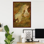
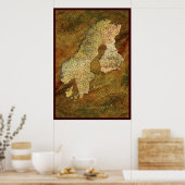
SCANDINAVIAN MAP Art Poster II
About our "Map of Scandinavia" (Version II) created by Skye Ryan-Evans
This version of the map is presented on an organic-looking leather-effect background. I decided to include Finland in the Scandinavian grouping partly because of balanced map aesthetics and partially because Finland is often considered part of the Scandinavian family of nations by many people around the World. I have included a little research from the online Wikipedia for your enjoyment and edification.
Scandinavia[1] is a region in northern Europe that includes Denmark, Norway and Sweden. Finland is often considered a Scandinavian country in common English usage, and Iceland and the Faroe Islands are sometimes also included.[2]
Scandinavia extends to the north of the Arctic Circle, but has relatively mild weather for its latitude, owing to the Gulf Stream. Much of the Scandinavian mountains have an alpine tundra climate. There are many lakes and moraines, legacies of an ice age about 10,000 years ago. The northern regions of Scandinavia are home to the indigenous Sami people.
Scandinavia has, despite many wars over the years since the formation of modern nation-states in the 10th century, been politically and culturally close. The constellations and alliances, however, have shifted over the centuries. For all of the 15th century, Scandinavia was united in the Kalmar Union. In the 19th century a new political union was proposed, but it did not take place when Denmark was denied key military support in a conflict with Prussia. Today, the nations cooperate mainly in the European Union or the Nordic Council.
The Danish, Faroese, Icelandic, Norwegian and Swedish languages are linguistically classified as North Germanic languages (also called Scandinavian languages), while the Finnish and Sami languages are classified as members of the Finno-Lappic group of the Uralic language family, unrelated to the Scandinavian languages. Danish, Norwegian and Swedish form a mutually intelligible dialect continuum, which is seen as a defining characteristic of Scandinavia as a modern cultural and linguistic entity.
Source: http://en.wikipedia.org/wiki/Scandinavia
25% of royalties from the sale of this beautiful new cartographic creation is donated directly to the Red Cross Haiti Relief effort.
Thank you for helping me to help this very worthy cause.

Avis des clients
4.7 sur 5 étoiles7 Nombres de Commentaires
7 Commentaires
Avis sur des produits similaires
5.0 sur 5 étoiles
5 sur 5 étoilesPar F.22 juillet 2016 • Achat sécurisé
impression, Taille: 44,13cm x 65,79cm, Matériel: Aucun, Cadre: Aucun, Format: Qualité (semi-brillant), Mat: Standard,
Programme d'évaluation de Zazzle
Finalement! Ma commande est arrivée intacte! Yuppiii!
Et oui celle-ci était la deuxième envoyée par Zazzle...
Ma première commande étant arrivée abîmée (photos incluses), je me suis mis en contact avec le Support de Zazzle qui m'ont proposé un deuxième envoi, à leurs frais.
Merci Zazzle!!
(le transporteur UPS m'a présenté ses excuses). Les couleurs sont parfaites. Imprimées en mat, le support papier est assez solide et consistant, mieux que d'autres posters achetés dans des magasins.
5.0 sur 5 étoiles
5 sur 5 étoilesPar B.7 juin 2021 • Achat sécurisé
impression, Taille: 38,06cm x 31,16cm, Matériel: Aucun, Cadre: Aucun, Format: Qualité (semi-brillant), Mat: Standard,
Programme d'évaluation de Zazzle
Produit de très bonne qualité, belle finition semi-brillante. L'impression est impeccable
5.0 sur 5 étoiles
5 sur 5 étoilesPar Ness L.14 janvier 2021 • Achat sécurisé
impression, Taille: 40,64cm x 50,80cm, Matériel: Aucun, Cadre: Aucun, Format: Qualité (semi-brillant), Mat: Standard,
Programme d'évaluation de Zazzle
satisfait - ce papier d'archive permet un collage facile sur panneau de bois. représente bien les details de l'original
Tags
Autres infos
Identifiant du produit : 228458016876973665
Fabriqué le 14/06/2010 18:19
Évalué G