

A propos de Posters
Vendu (e) par
À propos de ce design
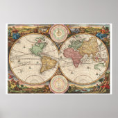
Poster Antique map of the world
A fine 1730 world map was drawn by Daniel Stoopendaal (Netherlands) for publication in the Keur Bible. Based on Visscher’s very similar map of 1663, this map depicts the world on a hemisphere projection surrounded by stunning allegorical cartouche work. The cartouche work corresponds to that seen on the second world Bible map produced by Nicolaas Visscher, Orbis Terrarum Tabula Recens Emendata ... (Shirley 431, 1663), though the map has changed to accommodate evolving geographical suppositions. Stoopendaal revisions of Visscher’s work include geographical updates as well as the incorporation of Copernican and Ptolemaic solar systems in the place of Visscher’s polar projections – though curiously Visscher’s labels remain. Cartographically Stoopendaal probably references Pieter Goos world map of 1666, Orbis Terrarum Nova Et Accuratissima Tabula ... (Shirley 438), to which this map is similar. . Our survey of this map will begin in North America where Stoopendaal has updated Visscher’s model to incorporate the convention of a flat topped insular California. The concept of an insular California first appeared as a work of fiction in Garci Rodriguez de Montalvo's c. 1510 romance Las Sergas de Esplandian, where he writes Know, that on the right hand of the Indies there is an island called California very close to the side of the Terrestrial Paradise; and it is peopled by black women, without any man among them, for they live in the manner of Amazons
Courtesy: Geographicus Rare Antique Maps
This media file is in the public domain in the United States. This applies to U.S. works where the copyright has expired, often because its first publication occurred prior to January 1, 1923.

Avis des clients
4.7 sur 5 étoiles7 Nombres de Commentaires
7 Commentaires
Avis sur des produits similaires
5 sur 5 étoiles
Par B.7 juin 2021 • Achat sécurisé
impression, Taille: 38,06cm x 31,16cm, Matériel: Aucun, Cadre: Aucun, Format: Papier pour affiche économique (semi-brillant), Mat: Standard,
Programme d'évaluation de Zazzle
Produit de très bonne qualité, belle finition semi-brillante. L'impression est impeccable
5 sur 5 étoiles
Par F.22 juillet 2016 • Achat sécurisé
impression, Taille: 44,13cm x 65,79cm, Matériel: Aucun, Cadre: Aucun, Format: Papier pour affiche économique (semi-brillant), Mat: Standard,
Programme d'évaluation de Zazzle
Finalement! Ma commande est arrivée intacte! Yuppiii!
Et oui celle-ci était la deuxième envoyée par Zazzle...
Ma première commande étant arrivée abîmée (photos incluses), je me suis mis en contact avec le Support de Zazzle qui m'ont proposé un deuxième envoi, à leurs frais.
Merci Zazzle!!
(le transporteur UPS m'a présenté ses excuses). Les couleurs sont parfaites. Imprimées en mat, le support papier est assez solide et consistant, mieux que d'autres posters achetés dans des magasins.
5 sur 5 étoiles
Par Ness L.14 janvier 2021 • Achat sécurisé
impression, Taille: 40,64cm x 50,80cm, Matériel: Aucun, Cadre: Aucun, Format: Papier pour affiche économique (semi-brillant), Mat: Standard,
Programme d'évaluation de Zazzle
satisfait - ce papier d'archive permet un collage facile sur panneau de bois. représente bien les details de l'original
Tags
Autres infos
Identifiant du produit : 228772354905023699
Fabriqué le 28/09/2011 7:18
Évalué G
Articles vus récemment